Geographical Misconceptions: Part Three

I seem to be on a roll of adding to the diverse range of my previous blog posts. In 2021, I published the first Geographical Misconceptions blog post, and two years later, I published the second. Since it appears it takes me two years to create one of these, which is the same rate at which a Sonic the Hedgehog movie is released, I thought I would continue that tradition.

To recap what I’m talking about when I mention misconceptions, I’m referring to a piece of information that people believe to be true, that in reality is false. But before I continue, why should I care about misconceptions that are geographical in nature?

To be honest, some misconceptions are innocent and localised, but others are widespread. When I hear misconceptions, they grind my gears, so the Vulcan part of me is compelled to insert logic into the conversation and to push back against the misconception. 1

The biggest talking point is that I don’t want adults continuing to spread the incorrect information to other adults, but mainly I don’t want children being taught these misconceptions, because they will grow up believing them to be true, have children of their own and continue to spread the misconceptions. That and eating Sour Cream and Chives. Kids need to be aware of the dangers of that flavour, since “Fair is foul, and foul is fair”. 2

So, let’s pull up our socks, step into our gumboots and traverse into the unknown that is a Some Geek Told Me blog post, and discuss some geographical misconceptions that get my undies in a twist. Lead on!


Image by Gundula Vogel from Pixabay

The Amazon is the longest river in the world

Anybody repeating this misconception could be forgiven, because it’s a close call. The Amazon River is one of the longest rivers in the world, spanning a whopping 6,400 km across seven countries in South America. However, this would be a strange misconception if the Amazon were, in fact, the longest river in the world.

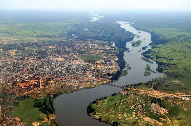
The Amazon River is the second-longest river in the world. The gold medal goes to the Nile River, which stretches across 11 African countries, roughly 6,650 km.

Nile River basin and its drainage network. Credit: Encyclopædia Britannica, Inc.

I need to add two points to this misconception: Firstly, it’s worth noting that rivers are constantly changing because of different environmental factors, and it can be problematic to decide and identify where a river starts, especially its source.

The second point is that there seems to be a campaign to crown the Amazon as the longest river, because the lengths are disputed, along with the fact that the Amazon has a higher discharge volume. Until the title has officially been stripped from the Nile, it’s still safe to say the Nile is the longest river on the planet.

Aerial view of the Baḥr Al-Jabal (Mountain Nile) and Juba, South Sudan. Credit: Frontpage/Shutterstock.com

New Zealand is an island/New Zealand only has two islands

I’m obviously biased here, but having lived in other countries, the subject of New Zealand consisting of only one or two islands is not a new misconception to me. Occasionally, the question would come up, and I would have to politely and tactfully explain the truth.

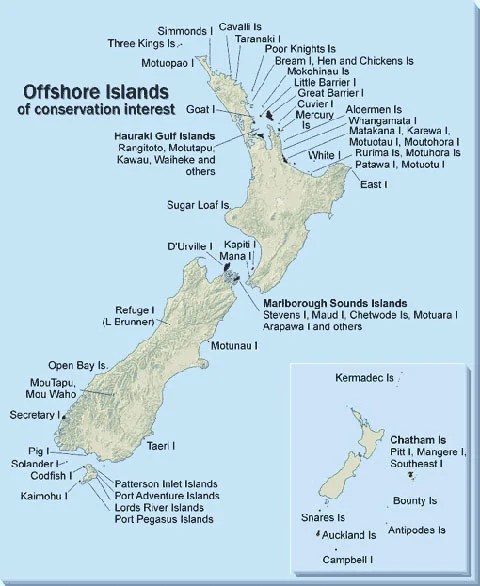
To set the record straight, New Zealand, like many other nations around the globe, is made up of several islands. Granted, the two main islands are the North Island (Te Ika-a-Māui) and the South Island (Te Waipounamu). The South Island is larger, while the North Island holds about 75% of the population.

During the last ice age, about 18,000 years ago, the two islands were connected by a land bridge when sea levels were lower. When the ice age ended, the land bridge was submerged when the sea levels rose, which resulted in the formation of the Cook Strait, the body of water that separates the two islands.

Located off the southern coast of the South Island is Stewart Island (Te Punga o Te Waka-a-Māui), which is the third largest island in the country. New Zealand consists of over 600 islands, including the Subantarctic Islands. Approximately 16 of these islands are inhabited. Therefore, it’s wrong to say that New Zealand has only one or two islands.

Map of offshore New Zealand islands. Credit: Department of Conservation 

Istanbul is the capital city of Türkiye

Can you name any city in Türkiye other than Istanbul? Istanbul is the most well-known Turkish city the world knows, so it has to be the capital city, right? The computer says no. 3

Like many cities on Earth, Istanbul is the most famous city in its country, or even the largest, but these two factors do not automatically mean it’s the capital.

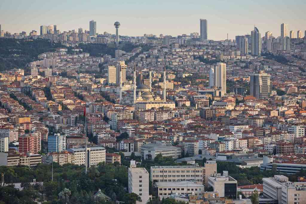
Istanbul has a population of about 15 million, which works out to be roughly 18% of Türkiye’s population, so it is large, but it’s not the capital city; although it was the capital of the Ottoman Empire until 1922. That honour goes to Ankara, with a population of 5.2 million, and it’s been the capital of many empires over the years.

After the Turkish War of Independence and the fall of the Ottoman Empire, the Republic of Turkey was formed. Ankara was officially made the capital on 29th October 1923, since the administration of the country was moved from Istanbul to Ankara.

Ankara, the capital city of Türkiye. Credit: Türkiye Visa

The Himalayas are the longest mountain range on the planet

This is an easy misconception to believe, because it makes sense that they would be. Firstly, the Himalayas are the world’s highest mountain range, averaging 6,000 to 6,100 m. It’s rather obvious when nine of the ten highest mountains above sea level are found in the Himalayas, especially with Mount Everest, the highest mountain on the planet above sea level, measuring 8,848.86 m.

But, we were asking about the longest mountain range on the planet, were we not? Correct, because it’s not the Himalayas; it’s the Andes. Stretching along South America’s spine, it covers 8,900 km through Argentina, Chile, Bolivia, Peru, Ecuador, Colombia, and Venezuela, and is 200 to 700 km at its widest. The Andes are the longest mountain range above sea level on the planet.

Now, if you were paying attention, I mentioned something odd. Similar to Mount Everest being the highest mountain in the world above sea level, the same can be applied here. The Andes are the longest mountain range in the world, but only above sea level.

The longest mountain range on Earth is actually underwater: the Mid-Ocean Ridge. The Mid-Ocean Ridge is found around the world, as it is interconnected by plate tectonic boundaries. These underwater ridges are part of a global Ocean Ridge system, which covers every ocean.

The mountain range is continuous, and it spans over 65,000 km, making it several times longer than the Andes. The Mid-Atlantic Ridge alone stretches 16,000 km. So to clarify, the Andes are the longest mountain range above sea level on the planet, but the Mid-Ocean Ridge is the longest in total.

The Andes mountain range as seen from a plane, between Santiago de Chile and Mendoza, Argentina, in summer. Credit: Jorge Morales Piderit.

The United States of America only borders two countries

This is yet another misconception, which, in my humble opinion, is quite understandable, why people would think this is true. Yes, the United States of America does indeed border two countries, notably two land borders.

The infamous Southern border, where apparently the world’s supply of drug dealers, criminals, rapists, and murderers enters the United States, which borders along the southern end of the continental United States and Mexico.

The Northern border, which you don’t need to be a brain surgeon to understand, shares two borders with Canada. The first and most obvious border is on the northern side of the continental United States. The second border with Canada is shared through Alaska, because, as we all know, “Alaska is part of the United States.”

So, to recap, the United States shares borders with Mexico and Canada, though they are land borders. And this is where the misconception comes into effect, because the United States also has maritime borders, or water borders.

It shares a maritime border with Russia, yes, I said Russia. It’s a de facto boundary between the two countries across the Bering Strait, because of Alaska’s location and position relative to Russia’s easternmost islands.

The United States also have many dependencies, territories and islands in the Pacific Ocean, Atlantic Ocean, Gulf of Mexico, and the Caribbean Sea. This results in the United States having maritime borders with The Bahamas, Cuba, Dominican Republic, Japan, Marshall Islands, Kiribati, and Federated States of Micronesia, as well as collective and/or disputed borders with Jamaica, Haiti, Colombia, Honduras, Nicaragua, Samoa, Tonga, Cook Islands, Niue, Tokelau, Sint Maarten, the British Virgin Islands, and Anguilla.

Because some of these countries are dependencies and territories of other countries, the United States, by extension, also shares maritime borders with Venezuela, New Zealand, the United Kingdom, and the Netherlands.

A map to the 1990 USA-USSR maritime boundary agreement. Credit: Bureau of European and Eurasian Affairs.

How did I do with explaining these geographical misconceptions? Do you have any of your own? As always, please let me know.

And that is another blog post for another week. Just to give everybody a heads up, my Christmas break is coming up soon, where I will take the second of my two annual holidays away from New Zealand’s 5th least favourite website. The dates have to be confirmed with the staff, but I’ll let you know soon.

Also, if you can’t back yourself, nobody else will, so in that vein, I would like to remind everybody that my Twitter and Mastodon accounts still exist, so please drop by. I’m aiming to one day get 50 followers on Twitter and 200 followers on Mastodon. I seem to be more popular on Mastodon than Twitter, though the reasons are probably, like Destruction, Desire and Dream, endless.

The 2026 FIFA World Cup and 2027 Rugby World Cup schedules have been recently drawn, so I’m still processing New Zealand’s games in both of these tournaments. I may have to post a reaction to them. Maybe. Are you happy with either draw or Netflix’s monopoly purchase?

Thanks again for reading, following, and subscribing to Some Geek Told Me. Please remember to walk your dog, read a banned book, don’t commit war crimes, and I’ll see you next week.


1. It’s always nice to sneak in a Star Trek reference.

2. Like wise for Shakespeare references as well.

3 In 2022, the government of Turkey officially changed its name to Türkiye, which was adopted by the United Nations.

Can a country have Dissociative identity disorder?  

Flags, flags, flags, I love a good flag. I live in an area where there are four houses within walking distance of my home that have a flagpole. A few weeks ago, I was walking along when I noticed a flag slightly flying on one of them. I could make out that the flag had orange and black on it.

I suddenly realised I had no idea whose country it belonged to, let alone the continent. Orange and black, orange and black. I was going to memorise the flag, then search for it later on. What country just had orange and black on their flag?!

As I walked closer and closer, I searched the bottom of the flag knowledge file in my mind for any possible answers. Because of the angle I was facing, the majority of the flag wasn’t revealed until I was three houses away.

It was then that I made the discovery that delighted and frustrated me; it was a Halloween flag featuring a witch. This mundane incident obviously triggered my Geek-sense, and the idea grew into the amazing blog post you are now reading.

Just over three years ago, I published my first and only blog post about flags, which can be discovered here. In that literary masterpiece, I discussed four countries’ flags that are no longer in use, for various reasons.

In some circles, three years is the perfect length of time for a sequel, so where is The Batman: Part II? To extend upon this, I have decided to create a sequel to that blog post, but this time, to simply discuss one country, whose history of name changing and flag swapping would make a swinger’s head swivel.

So, sit back, relax, and put your tray table away, because we’re going to look at one country’s many failed flags.


DR Congo’s location in Central Africa, marked by a pin of its national flag. Credit: Mappr

Democratic Republic of the Congo (Formerly known as the Congo Free State/Belgian Congo/Republic of the Congo/Democratic Republic of the Congo/Zaire)

The Democratic Republic of the Congo is odd because it doesn’t just have a few national flags, but several, although it’s the same country; but at the same time, it’s six countries. I told you it was odd.

We have to venture to Central Africa, and to explain the Democratic Republic of the Congo, I need to explain Zaire. In order to explain Zaire, I need to explain the Democratic Republic of the Congo; and to explain the Democratic Republic of the Congo, I need to explain the Republic of the Congo. But to explain the Republic of the Congo, I need to explain the Belgian Congo. However, to explain the Belgian Congo, I need to explain the Congo Free State. It’s like Russian nesting dolls filled with flags and countries.

The Congo Free State

Flag of Congo Free State (1885–1908).
Credit: Public domain, via Wikimedia Commons

Starting with the Congo Free State is arguably the best country to begin with. The flag has a blue background with a yellow star in the centre. It was first introduced when the Congo Free State was a de facto African colony of Belgium, but more importantly, it was controlled by King Leopold II of Belgium.

Also, in a totally random and unrelated coincidence, the Congo Free State shared its flag with the International Association of the Congo or the International Congo Society, which was set up by King Leopold II of Belgium, to further his interests in the region. What are the odds of that happening?!

Belgian Congo

Flag of Belgian (1908-1960).
Credit: Public domain, via Wikimedia Commons

In 1908, the Congo Free State was officially annexed by the Belgian government, so the country was renamed the Belgian Congo, but they decided to retain the flag. That was nice of them, considering the atrocities the Belgians committed upon the Congolese, in the pursuit of rubber, ivory and minerals.

Republic of the Congo or Congo-Léopoldville (Not to be confused with its neighbour, the Republic of the Congo)

Flag of the Republic of the Congo (1960–1963). Credit: Public domain, via Wikimedia Commons.

In 1960, the Belgian Congo declared independence from Belgium. Among civil unrest and wars that plagued the newly (re)minted country, the nation’s name changed for a second time to the Republic of the Congo, along with a tweaked version of the original flag, namely, the vertical column of six five-pointed stars on the left-hand side.1

Flag of the Republic of the Congo (1963-1966). Credit: Public domain, via Wikimedia Commons

Three years later, in 1963, the flag was changed yet again to another similar, but different version. This new flag still had the original yellow star, but it was smaller and had been moved to the top corner of the left-hand side. It also had a red and yellow-lined band that ran diagonally across the centre. The star represented unity, the yellow symbolised prosperity, the blue stood for hope, and the red reflected the people’s blood.

In 1964, the call was made to change the official name of the Republic of the Congo to the Democratic Republic of the Congo, because why the hell not?

Democratic Republic of the Congo

Flag of the Democratic Republic of the Congo (1966-1971). Credit: Public domain, via Wikimedia Commons

Just like how a classic comic book character like Daredevil is relaunched with a new #1, and then three years later, he has yet another relaunch with another #1, the same applies here. In 1966, because three years in an eternity in politics, the government decided the national flag needed an update, because if the country has a new name…it needs a new flag.

This flag was identical to the previous one, but for two small changes. The red band has widened, and the yellow star has decreased in size.

Zaire

Flag of Zaire (1971–1997). Credit: Moyogo.

To offer a recap, the Congo Free State rebranded itself to become the Belgian Congo, then changed into the Republic of the Congo; along with several flag alternations, and another name change to the Democratic Republic of the Congo. By 1971, you would think that the days of the country’s name and flag changing were over. However, to quote John Rambo, “Nothing is over! Nothing!”

The Democratic Republic of the Congo was renamed Zaire to shake off its colonial past and embrace its African heritage and culture. The new name came with a new flag, which included the Pan-African colours of red, yellow, and green.

The green background represented hope and the country’s fertile land; the yellow symbolised the country’s prosperity and bountiful natural resources, and the red stood for the blood shed for independence and the nation’s martyrs.

The circle with the flaming torch represented the unity of the Zairean people, as well as being a symbol of the ruling party, the Popular Movement of the Revolution (MPR).

Democratic Republic of the Congo (Again)

Flag of Democratic Republic of the Congo (1997-2003). Credit: Public domain, via Wikimedia Commons

The government was overthrown in 1997, which, you guessed it, brought about a new name and flag. The name Zaire was dissolved, and the Democratic Republic of the Congo was reintroduced, along with updating the flag. Instead of looking to contemporary times for inspiration to redesign the flag, it was decided to dive back into the past, 1960, to be correct, to find the next flag.

The new, but old flag was a variation of the first Republic of the Congo’s flag, which was adopted in 1960. The number of stars and their yellow colour didn’t change, but the central star is slightly smaller, along with a lighter blue background.

Flag of the Democratic Republic of the Congo (2003–2006). Credit: Moyogo.

When the Democratic Republic of the Congo was just six years old, a decision was made that the national flag needed to be updated. As a result, the flag underwent a makeover. Perhaps someone was allergic to the original blue or felt that it wasn’t light enough, but whatever the reason, the blue on the flag was changed to a lighter shade, and the size of the central star was also adjusted.

In my personal opinion, I think some ministers’ OCD was out of control.

Flag of the Democratic Republic of the Congo (since 2006). Credit: Nightstallion.

By now, you would have guessed what happened in 2006, three years after the Democratic Republic of the Congo’s third flag was revealed. Yes, we have another flag change. 10 points to Hufflepuff!

You can’t make this stuff up, but in 2006, the wheel turned again, and another flag was introduced. It’s a hybrid of the Democratic Republic of the Congo’s first and third flags, combining the design of the 1966 flag, but using the blue from 2003’s flag.

If I understand it properly, the star represents the future for the country, red is for “the blood of the country’s martyrs”, the country’s wealth is yellow, and the blue stands for peace.

Next year will mark the 20th anniversary of the Democratic Republic of the Congo’s current flag, and long may it last. However, like a married man having a midlife crisis, who starts dating a woman old enough to be his daughter, will the Democratic Republic of the Congo have another makeover, via a name and flag change? Who knows?

I hope this blog post was coherent enough to understand, because as I was writing it, I kept saying to myself, “This makes no sense, but it’s true.” As always, please let me know your thoughts on the subject.

Writing about the Democratic Republic of the Congo’s flags and name changes has given me a small headache, so I’m done. Thanks again for reading, following, and subscribing to Some Geek Told Me

Please remember to walk your dog, read a banned book, the world is a vampire, and I’ll see you next week.


1.) When the Republic of the Congo was named, its neighbour was also called the Republic of the Congo. To sort through the confusion and help the international community differentiate between the two Congos, the flags were different.

In addition to this, the Republic of the Congo was referred to as Congo-Léopoldville, acknowledging its Belgian past. And not to be outdone, the Republic of the Congo was known as Congo-Brazzaville, acknowledging its French heritage. Not confusing at all.